Description
Features
Unparalleled Efficiency and User Experience
Import images with ease while navigating the intuitively designed interface effortlessly.
Bulk process up to 400 images/1 GB of RAM, minimizing the wait time between fieldwork and digital visualization.
Meet and Exceed Your Project Standards
Generate highly detailed 2D orthomosaics and 3D models with enhanced absolute accuracy by setting Ground Control Points (GCPs) and checkpoints, so you can measure and inspect with ease.
View a quality report of your mission to ensure the results meet your accuracy standards.
Compatibility and Flexibility
Convert the coordinates of your maps and models into 8500+ major coordinate systems by simply selecting the output that fits your needs.
Incorporate POS data, GCPs, or both sets of data to create georeferenced maps and models with enhanced accuracy directly in the target coordinate system required by the project.
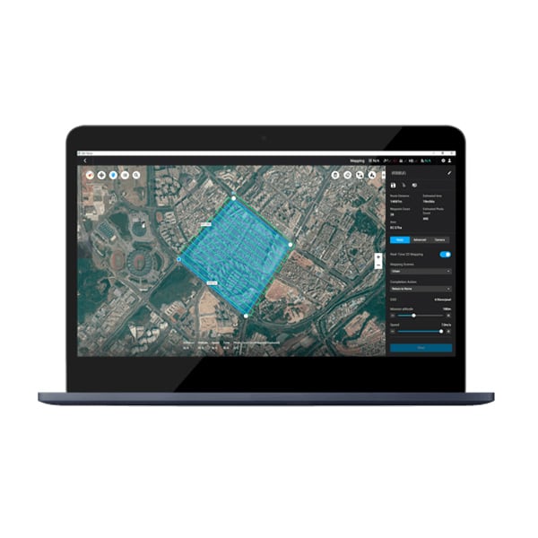
Real-time Mapping
Quickly generate a 2D orthomosaic of the selected area in real-time. Not only is this ideal for creating detailed flight paths in remote areas but it’s also useful for time-sensitive missions that require quick decision-making on site.
 »")
 »")
 »")
2D Reconstruction
Generate high resolution orthomosaics, enabling you to get detailed and accurate measurement results for all your critical projects.
2D Multispectral Reconstruction
Process multispectral images to generate vegetation index maps including NDVI and NDRE. Create prescription maps for variable rate application using DJI’s Agras drones to improve crop yields while driving down costs.
Real-time 3D Point Cloud
When efficiency is key, quickly render and visualize a 3D point cloud of the mapped area. Make decisions based on the preliminary model and check for completeness immediately or plan 3D flights on-site.
3D Reconstruction
Get sharp and realistic representations of your surroundings throughout various industrial applications, be it accident reconstruction, recreating thin power lines and complex vertical structures, managing major construction projects and more. The CUDA-based reconstruction algorithms are capable of quickly processing large amounts of data to deliver quality results.